Caen Defence Overprint – Stormont, Dundas & Glengarry Highlanders
Depicting the German defences and regimental movements during the liberation of Caen.
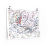
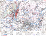
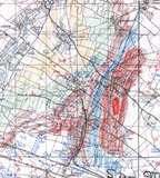
This original defence overprint map comes from the war diary of the Stormont, Dundas & Glengarry Highlanders, one of Canada’s frontline infantry regiments during the Battle of Caen. The map shows in remarkable detail the German defensive positions outside the city and is uniquely shaded between contour lines to illustrate elevation and terrain.
A hand-drawn annotation traces the path taken by the regiment during the liberation of Caen, capturing both the tactical situation and the personal touch of the soldiers who fought there. This blend of official military cartography and first-hand record makes it one of the most distinctive Canadian maps of the Normandy campaign.
Product Details:
-
Printed on 175gsm premium fine-art paper
-
Matte finish for an authentic archival appearance
-
Created from high-resolution scans of the original 1944 map
-
Shows German defences, contour shading, and regimental movement
-
Ideal for collectors, historians, educators, and battlefield visitors
-
Ships worldwide in protective packaging
A rare reproduction of the Stormont, Dundas & Glengarry Highlanders’ Caen defence map, blending artistry, field record, and the reality of battle in Normandy.


