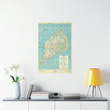
The volcanic island that tested the resolve of a generation.
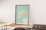
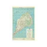
This detailed Special Target Map of Iwo Jima was prepared in advance of the Allied invasion in February 1945. It depicts the island’s complex terrain, including Mount Suribachi, the airfields, and the heavily fortified beaches that became the scene of one of the fiercest battles of the Pacific War.
Used for operational planning, this map identifies key objectives, defensive positions, and topographical challenges faced by the U.S. Marine Corps during the assault. Every contour and annotation reflects the immense preparation required to capture the island that would provide a critical air base for the bombing campaign against Japan.
This facsimile preserves the vivid colour, detail, and accuracy of the original wartime map — a powerful artefact of a battle remembered for its intensity, sacrifice, and the iconic flag-raising atop Mount Suribachi.
Product Details:
-
Printed on 175 gsm premium fine-art paper
-
Matte finish for an authentic archival appearance
-
Created from high-resolution digital scans of original wartime documents
-
Displays airfields, defensive networks, and key objectives
-
Ideal for collectors, historians, educators, and military enthusiasts
-
Ships worldwide in protective packaging
A striking reproduction of the map that guided one of the most pivotal and hard-fought battles of the Pacific campaign.


